Existing Integrations
August 27th, 2025
COTAK Team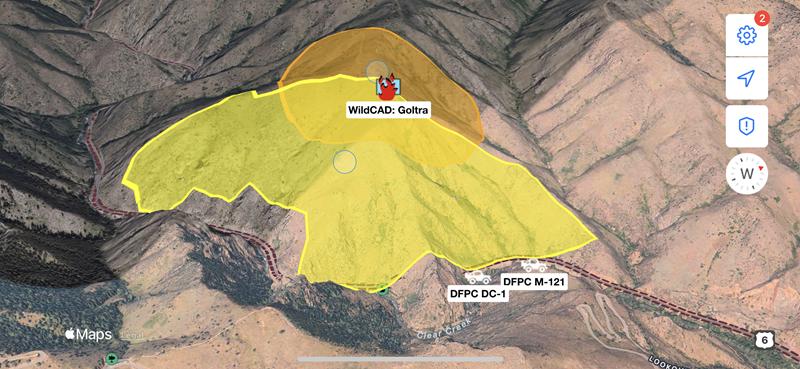
The COTAK team will develop new integrations on a best-effort basis, free of charge to COTAK member agencies. Additionally, the following existing integrations can easily be deployed as needed to support COTAK member agencies:
- Active911 - Active911 alerts
- AirData UAV - Live video from the AirData system when a drone connected to the platform is in flight
- ArcGIS Feature Services - Data can be written from ArcGIS feature services to TAK, and TAK user locations can be written to ArcGIS for viewing in ESRI products
- This integration is utilized on the CO Wildland Fire MAC channel to provide the locations of currently burning wildland fires & prescribed burns reported to federal dispatch centers, and the locations of lightning strikes from the last 72 hours.
- Axon Body Cameras - Locations of Axon Body Cameras (but not the live video from the camera), with options to set if locations are shared only when cameras are recording/activated
- COtrip - Data from the COtrip system operated by the Colorado Department of Transportation
- This integration is utilized on the CO Highway MAC channel to provide the locations of CDOT snow plows and other vehicles, and the locations of traffic incidents reported to CDOT.
- DroneSense - The location of a drone flown using DroneSense, and the location the drone's camera is pointing. A link to watch live video from the drone in a web browser is also available.
- Everywhere Hub - Locations of satellite messenger devices operated via Everywhere Hub
- Garmin inReach - Locations of Garmin inReach devices
- GeoJSON - Strings formatted as GeoJSON
- GeoTab - Automated vehicle locator (AVL) data from GeoTab accounts
- Optimus Tracker - Locations from Optimus Tracker
- SARTopo - Locations of personnel using SARTopo, as well as points and lines collected in SARTopo
- Spidertracks - Locations of aircraft equipped with Spidertracks devices
- SPOT - Locations of SPOT devices
- Skymira - AVL data from SkyMira accounts
- WildCAD - Locations of wildland fires, prescribed burns, smoke reports, and other incidents reported to interagency wildland fire dispatch centers covering Colorado


